Dorey Family of Susan J. Dorey: History and Geography of Jersey and Nova Scotia
My Doreys immigrated from Jersey, an island in the English Channel, to the Canadian Province of Nova Scotia in the early 1800s, especially to Arichat on Isle Madame. This page outlines the history and geography of these two countries with emphasis on things pertinent to the Doreys.
Brief History of Jersey
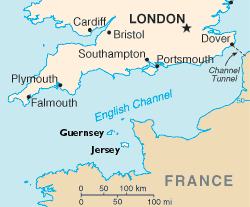
Jersey is about 20 miles offshore from mainland France. It is closer to France than England. And almost 2000 miles east of Nova Scotia.
Romans occupied Jersey (named Caesarea) from around 56 AD although it was not a significant outpost. In 511 Jersey became part of the kingdom of Neustria. It was around this time that the first Christian missionaries arrived in Jersey—St Magloire and St Samson.
During the 800s Jersey was plundered again and again by Vikings. These raids continued until 911 AD when France purchased peace with the Vikings.
 In 933 Jersey, with the other Channel Islands, was annexed by William Longsword, Duke of Normandy and son of the Viking Rollo.
In 1066 William, Duke of Normandy, defeated Harold at the Battle of Hastings, was crowned King of England,
and became known as William the Conqueror; he was the great great grandson of William Longsword.
From 1066 to 1204, England, Normandy and the Channel Islands were thus united under one rule—that of the
King of England who was also Duke of Normandy. But England and Normandy were administered separately from
London and Caen respectively with different languages, laws, and money.
The Channel Islands continued to be regarded as part of Normandy, and were subject to Norman Customary Law and
local customary rules. In 1204 King John lost Normandy to King Philippe-Auguste of France, after which
John provided for fairly independent government of the Channel Islands under his jurisdiction.
Several attempts were made by the French to subjugate the Islanders, but all failed.
In 933 Jersey, with the other Channel Islands, was annexed by William Longsword, Duke of Normandy and son of the Viking Rollo.
In 1066 William, Duke of Normandy, defeated Harold at the Battle of Hastings, was crowned King of England,
and became known as William the Conqueror; he was the great great grandson of William Longsword.
From 1066 to 1204, England, Normandy and the Channel Islands were thus united under one rule—that of the
King of England who was also Duke of Normandy. But England and Normandy were administered separately from
London and Caen respectively with different languages, laws, and money.
The Channel Islands continued to be regarded as part of Normandy, and were subject to Norman Customary Law and
local customary rules. In 1204 King John lost Normandy to King Philippe-Auguste of France, after which
John provided for fairly independent government of the Channel Islands under his jurisdiction.
Several attempts were made by the French to subjugate the Islanders, but all failed.
Over the next few hundred years, Jersey was invaded several times by the French with possession of the island switching back and forth between the English and French six times. In 1356 the French formally abandoned claims to the island in the Treaty of Calais. But French control returned from time to time through the 1400s.
By the 16th century Jersey fishermen had begun fishing off Newfoundland. This was interrupted by political unrest, but resumed after 1781. As small settlements grew up across the Atlantic, the demand for ships meant that shipbuilding became one of Jersey's main trades.
During World War II Jersey was invaded by the Germans. By December 1940 there were 1,750 Germans on Jersey. Within a year this had increased to 11,500. Jersey was liberated on May 9, 1945.
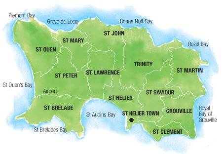 Jersey is divided into 12 parishes, among them Trinity, St. Helier, St. Peter, and St. Lawrence.
Many Jersey folk are members of the Church of England. They speak a special dialect of French: Jèrriais (also known as Jersey Norman).
About Nova Scotia
Nova Scotia is a maritime province of Canada located on the Atlantic Ocean. Most of it is a peninsula separated from New Brunswick by the Bay of Fundy. There are also some islands, the largest being Cape Breton Island. Nova Scotia was settled by French beginning about 1600; these people called themselves Acadians. The province was named for the many Scottish immigrants who followed.
Cod, Gadus morhua, in the Grand Banks (off Newfoundland and Labrador) brought Europeans to Canada. The Basque were probably the first to salt them and bring them back to Europe to trade, and they got rich that way. Their salt cod business was well underway by 1490; their secretness preserved their exclusive business. The cat was out of the bag in 1497 when Giovanni Caboto, a Genovese with the English name of John Cabot, discovered Newfoundland with its sea teeming with cod, and claimed it for England. In his wake, cod was fished and salted by many countries and many fortunes were made. It played a role in the three-sided trade: molasses from Jamaica to New England, rum and cod from New England to Africa, slaves from Africa to Jamaica (to work the sugar plantations). The cod stocks began to fail by 1868. Extensions of Canada's sovereignty to its continental shelves, eventually to as far as 200 miles in the 1970s, followed by restrictions on its own fleet and, in 1992, a moratorium altogether on cod fishing, were too late to save the fish. Today there is no viable cod fishery in the western Atlantic: the fish are almost extinct from overfishing. But the people remain.
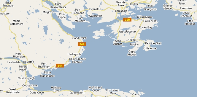
Arichat, the town most involved with the early Dorey immigrants, is on Isle Madame (an island located off the southeast coast of Cape Breton Island). Janvrin's Harbor, Janvrin's Island and the towns of Barrachois and D'Escousse are all on Isle Madame as are Pondville and Cap La Ronde. West Arichat was once known as Acadiaville. Petit de Grat is a community on its own island connected by causeway to neighbouring Isle Madame on its northwest corner; for convenience, I consider it a part of Isle Madame. The town of Guysborough is in the same–named county, southwest and across Chedabucto Bay (Atlantic Ocean) from Arichat, on the mainland of Nova Scotia; it was founded in 1654 by English Loyalists. L'Ardoise, Grande Greve, Grand River, River Bourgeois, Rocky Bay, and St. Peters are on Cape Breton Island, generally north and northeast of Isle Madame.
Beginning in 1755 the early French settlers were exported to make way for English settlers; the exportation involved deportation of the original families and burning and/or confiscation of their homesteads. This exportation took some Acadians to Louisiana were they became known as Cajuns. Henry Wadsworth Longfellow immortalized the Acadian expulsion in his epic poem "Evangeline" published in 1847. That poem is available on the web at Electronic Text Center, University of Virginia Library. The poem is also available at Poets.org.
"125 years ago Nova Scotia had one of the world's largest merchant fleets and did business in all corners of the world."
There is an excellent map at the Government of Nova Scotia's web site. It is a PDF file and is 1.6 MB in size (which is to say it takes a long time to open, even on DSL, but it is worth it). You can use the zoom tool to zero in on an area, say Isle Madame.
About Isle Madame
The island is 17 square miles in size, about 7 miles wide and 10 miles long, has 12 fresh-water lakes, and has no high elevations. It is connected to Cape Breton Island to the north by a bridge over the Lennox Passage and separated from the mainland of Nova Scotia to the west and south by Chedabucto Bay. The island is in Richmond County.
 Isle Madame was first
occupied by Europeans—mostly French, Basque, and Portuguese fisherman—in the 1500s and 1600s.
In 1752 there were about 35 Acadian families settled on Isle Madame.
The soil was deemed unsuitable for agriculture and cod fishing was the sole occupation.
Isle Madame was first
occupied by Europeans—mostly French, Basque, and Portuguese fisherman—in the 1500s and 1600s.
In 1752 there were about 35 Acadian families settled on Isle Madame.
The soil was deemed unsuitable for agriculture and cod fishing was the sole occupation.
After the Acadian expulsion, the island began to repopulate in the early 1760s. Beginning in 1764 Isle Madame was one of only two places in Nova Scotia, the other being Cape Sable, where Acadians were allowed to return to lands they had previously occupied. Acadians who had lived on Isle Madame before 1758, Acadians displaced from elsewhere, and newcomers from France and the Channel Islands re-established the fishing and coastal trading economy of Isle Madame. Arichat was founded in 1764; the name is evidently Micmac in origin, meaning the camping ground. Philip and John Robin, Jersey Huguenots, established a fishery at Arichat. They were the brothers of Charles Robin (1743-1824) the most important fish merchant in the Gaspé region. The Robin Company brought many young men from Jersey to man their fishing stations in the new world; they remained in business until the 1970s.
In 1774 there were 1,011 residents of Isle Madame, half of which lived in Arichat and Petit de Grat. During the American War of Independence in 1776, all but 6 families left the island and settled temporarily at Chezzetcook, just north of Halifax on the mainland. Many returned and resettled after the Armistice of 1783. Nova Scotia's anti–Catholic laws were abolished in 1784, which helped Isle Madame's rapidly expanding Acadian population. By 1786, the population had increased to such an extent that Arichat was assigned its own resident Catholic priest, making it the second oldest Catholic parish in Nova Scotia; the parish was founded by 70 families who, in a letter dated March 8, 1786, thanked the lieutenant governor of Cape Breton, J.F.W. DesBarres, for the promise of land concessions, the permission to construct a church and school, and the request for tax exemptions. Arichat's first chapel was built about 1786, under the direction of the missionary priest Pierre Bourg.
In the early 1800s Arichat was a major Atlantic Coast port in what became Canada in 1867. Its harbor is the fourth deepest in the world. Its waterfront was lined with two miles of wharves. The Arichat business community was led by Jersey-born merchants. Arichat ranked third after Halifax and Yarmouth in the amount of shipping. Arichat's Golden Age was during the American Civil War when its ships carried cod from Sydney and Pictou to New England.
Documents of the early settlers of Isle Madame are rare and difficult to find. Because the Acadians were in constant danger of being deported by the English, especially after the second deportation of 1758, they often built their homes in small coves, inaccessible by roads, and close to the sea. They were not allowed to own property, to vote, or to hold any public positions, and as a result left very few documents. Additionally, the earliest church records were completely destroyed when Arichat's first Catholic church burned on the night of November 23–24, 1838. The first official census of Cape Breton was conducted in 1752 and is still being translated from French into English (Inspection Voyage of Sieur de la Roque Census 1752).
I am largely quoting here from McAlpine's Maritime Provinces Directory for 1870–1871. Most of the change is the tense.
In 1870 Richmond County was the third most populous county in Cape Breton. It was almost exclusively a fishing and trading county, but there were a few farming settlements bordering the Bras d'Or Lake. Arichat was extensively engaged in fishing and trading. The leading houses were branches of Jersey establishments. Its inhabitants invested largely in shipping, of which several thousand tons were lucratively employed in the coal trade for a long time. Its capacious harbor, with two fine entrances, and furnishing ample accommodation for vessels of the largest class, left no room to doubt its ultimate importance as a seaport. It had telegraph cable communication, and a well-conducted ferry with the mainland. A packet, drawing Government subsidy, regularly plied to Guysborough.
The inhabitants of the county generally were of French descent, and fishing was the leading pursuit. Valuable coal mines existed at River Inhabitants and Caribou Cove. This county had several fine harbors; and the beautiful Passage of Lennox, as well as the sheets of water in the vicinity known as the Big and Little Basins, with their surrounding scenery, furnished a rich treat for the lover of Nature.
There is a "Doreys Lake" a bit northwest of Arichat and a "Doreys Point" on the northwest corner of Delorier Island. The Lake lies on land once owned by Moses Dorey in West Arichat, so is apparently named after him. I have yet to learn who the Point was named after, it is on land once owned by Louis Delorier, perhaps the map author erred in the name?
There is a small map at Samson genealogy website that names all the towns and roads where Doreys lived, with the exception of Barrachois. There is also a very large map by David Pivin which shows River Inhabitants and River Bourgeois on nearby Cape Breton Island.
In the fall of 1776 John Paul Jones, famous for saying "I have not yet begun to fight!", raided Isle Madame. Was he really a pirate or privateer as some have said? This account provides the details—dates and events—and evaluates his role. Certainly it was seven years before the fishing industry resumed.
West Arichat
West Arichat is on the Isle Madame three miles west of Arichat. West Arichat was at one time named Acadiaville since a number of Acadians settled there. It was also known as Little Arichat for a time when there was an active ship building industry there. The name was changed from Little Arichat to West Arichat by Provincial Statute in 1866. There was a school as early as 1836. In 1860 West Arichat was a bustling seaport, with seventy vessels (70,000 tons) mostly engaged in carrying coal and produce to the U.S. In 1904 there was a lobster factory. Ecclesiastically, West Arichat was a mission of Arichat until 1863 when it was made a separate parish. The church of the Immaculate Conception was opened here in 1876. A way office was established in 1854. West Arichat's population has declined since its peak: 1586 in 1881, 1004 in 1991, and 441 in 1996.
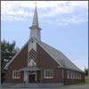
St. John's Anglican Church, Arichat
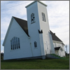 St. John's Anglican Church was founded by Jersey settlers in 1828.
The original structure was replaced in 1895 by the Oxford Construction Company of Oxford, Nova Scotia and is still in use today.
Prior to 1828 the residents were visited once or twice a year by the Anglican Rector of Sydney.
The first minister was Rev. James Allen Shaw.
St. John's Anglican Church was founded by Jersey settlers in 1828.
The original structure was replaced in 1895 by the Oxford Construction Company of Oxford, Nova Scotia and is still in use today.
Prior to 1828 the residents were visited once or twice a year by the Anglican Rector of Sydney.
The first minister was Rev. James Allen Shaw.
Many Doreys were baptized, married, and buried in this church.
Unfortunately not all church records have been transcribed into English or into electronic form.
The church records date "back to 1828 and are all intact and accessible to any interested parties.... [All]
your ancestors ... are recorded in the records of the [church]."
(per Marshall J. Bourinot, 7–10–1982, in a letter to Leander E. Dorey, my father).
One of the stained glass memorial windows in the church was placed by my Dorey family with the following inscription:
"To the Glory of God and in memory of — Wingate, Hattie, Henry, Margaret, Ada, Sophie, Carrie, Willie and Chester Leet Doré."
Notre Dame de L'Assomption Church, Arichat
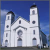 This is the sole Roman Catholic church in Arichat, Nova Scotia.
The church, established in 1756, was the frst church constructed on Isle Madame.
After a fire, it was rebuilt in 1837.
Arichat was the seat of the diocese from its inception in 1844 to 1886, with Notre Dame de L'Assomption as its cathedral.
The seat of the diocese was transfered from Arichat to Antigonish around 1886.
This is the sole Roman Catholic church in Arichat, Nova Scotia.
The church, established in 1756, was the frst church constructed on Isle Madame.
After a fire, it was rebuilt in 1837.
Arichat was the seat of the diocese from its inception in 1844 to 1886, with Notre Dame de L'Assomption as its cathedral.
The seat of the diocese was transfered from Arichat to Antigonish around 1886.
The Doreys were originally members of the Church of England, but some married Catholics and their births, marriages, and deaths are recorded in the parish records of Notre Dame.
Immaculate Conception Church of the Blessed Virgin Mary, West Arichat
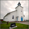 This is the sole church in West Arichat, Nova Scotia.
The Roman Catholic parish was first organized in 1862, while the church itself was built in 1871.
Fire destroyed the church records between the years 1862–1880 leaving an 18-year gap in family records.
The first church was destroyed by fire in 1967, the second one was built in 1977.
Some Doreys moved to West Arichat.
This is the sole church in West Arichat, Nova Scotia.
The Roman Catholic parish was first organized in 1862, while the church itself was built in 1871.
Fire destroyed the church records between the years 1862–1880 leaving an 18-year gap in family records.
The first church was destroyed by fire in 1967, the second one was built in 1977.
Some Doreys moved to West Arichat.
The parish was originally, from 1786 to Aug. 3, 1863, St. Hubert's Parish in Little Arichat. Father Jean B. Allain was there between 1798 and 1808.
St. Hyacinth's Church, D'Escousse
 St. Hyacinth's is a Roman Catholic church located in D'Escousse. The parish was created in 1844.
It is unknown when the first church was built. The second church was built about 1870 and destroyed by fire in 1954.
The third chuch, still standing, was built in 1955.
There are family records from 1831, but those for February 1844 to June 1856 are missing.
St. Hyacinth's is a Roman Catholic church located in D'Escousse. The parish was created in 1844.
It is unknown when the first church was built. The second church was built about 1870 and destroyed by fire in 1954.
The third chuch, still standing, was built in 1955.
There are family records from 1831, but those for February 1844 to June 1856 are missing.
Revision: 5-24-2023.